02

Construction
Construction companies are leveraging aerial imagery and data to secure video, photos and data to dramatically benefit the project.
As the UK becomes more densely populated, the construction industry is expanding at a significantly higher rate than ever before. Construction organisations now need to execute more complex architectural plans and naturally want to increase their competitive advantage in the market.
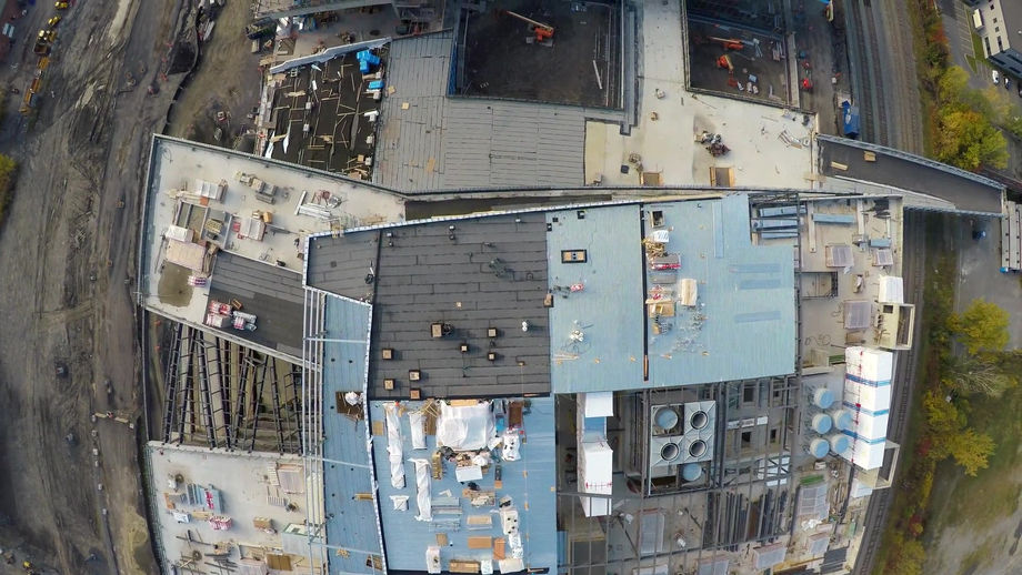
Leading construction projects are now benefiting from an aerial vantage point thanks to drone technology. It is now quicker and easier to get above a site and collect video, photos and data that can benefit a project.
In addition, construction managers can eliminate the need for human inspections by closely monitoring material stockpiles to ensure optimum supply levels.
Likewise, advanced drone technology and accurate imaging allows building inspectors to assess any building defects onsite or remotely using a desktop, again eliminating the need for large teams of workers that need to access walls and walk across scaffolding and rooftops.
SMALL PROJECTS BENEFITS
-
Small-scale projects can also benefit from a drone’s eye view. Securing a detailed measurements and land layout before construction begins can be invaluable.
TENDER AND CAPABILITY BENEFITS
-
Drones allow the creation of a catalogue of projects to demonstrate capability and potential as part of the sales and tendering process.
NOT JUST A PRETTY PICTURE!
-
Drone imaging goes well beyond just aerial pictures or videos. Accurate construction outputs and information can be gathered rapidly and be put to work on projects from the start.
-
Surveying
In the field or in the office, GIS professionals can access and analyse Geo-referenced aerial images and high-fidelity reconstructions of sites, allowing teams of professionals to make smart, efficient decisions.
The Geo-spatial (or surveying) industry is undergoing a revolution. Previously, it was total stations, then GPS, laser scanners and robotics. Now, surveying professionals are taking on another tool with great excitement – mapping drones. These drones boast quick data collection times, excellent positional accuracy, a safe operator experience and simply remarkable ROI.
Today, UAVs are considered the primary tool for safely capturing accurate aerial data quickly. Importantly, they can also create aerial maps and 360-degree virtual tours in real time, even before they’ve landed.
Survey specific drones deliver greater detail, higher map resolution and have the capacity to measure vital areas in centimeters, as opposed to meters. Taking advantage of mapping technology, surveyors can also create collaborative maps and 3D models.
In the field or in the office, GIS professionals can access and analyse Geo-referenced aerial images and high-fidelity reconstructions of sites, allowing teams of professionals to make smart, efficient decisions.
"Drones are changing traditional surveying."
TRADITIONAL VERSUS DRONE
-
Drones can vastly reduce the time spent on projects by collecting accurate surveying data in a much shorter time frame than traditional, costly and labour-intensive methods.
BUILT FOR THE INDUSTRY
-
Surveying professionals can now pick and choose a remarkable array of purpose-built drone technology for their industry and specific application.
SAFETY FIRST
-
Drones eliminate the need for humans to access hard-to-reach and dangerous terrain. Put simply, drone technology makes companies more efficient, profitable, and safe.


